
The blog series ‘In Focus‘ is conceived as a way to show the scope and diversity of the RELICS research group. Each month one of us will reflect on a current or recently finished project, and how it connects to the aims and vision of RELICS. Through this, by drawing from our own personal experience, we want to show in which ways Latin cosmopolitanism came to the fore from antiquity until modern times.
by Klazina Staat (Ghent University)
One of the many lessons of the covid-pandemic is that people (at least in the Western world) perceive a close link between travel and cosmopolitanism. Covid-19 has been called a “cosmopolitan virus”, because it travelled so rapidly around the world after its first discovery in late-2019. Ironically, people have also pointed out anti-cosmopolitanizing effects: it makes travel practically impossible and forces people to stay within the borders of a nation. Some have already announced the “death of cosmopolitanism”, assuming that unlimited traveling will no longer be possible in the future.
These responses implicitly propose that only by traveling one could escape national borders and reach the ideal ‘cosmopolis’: the city that gathers people from all over the world in a multicultural melting pot. This is a very Western idea, directly following from the rise of the nation state, increasing economic development, and mass tourism in modern Western Europe. It is not a reality for the many people who cannot travel because they are stateless, experience poverty and conflict, are unemployed or have a job that does not entitle them to free time. Moreover, it is highly different from the premodern idea of cosmopolitanism. Can the pre-modern concept of cosmopolitanism be of help for us, when the current covid-crisis and other global challenges force us to rethink our ways of living and traveling?
How did the medieval wo/man see the world? A crucial aspect of the medieval understanding of cosmopolitanism (and the two terms constituting the word) is the notion of order. Cosmos denotes the ‘natural’ world as it is created and organized by the divine creator. ‘Polis’ is the term used for the world of human society, organized by norms and laws that are created by humans. Both were believed to be governed by the same principles. Hence, it was possible to see the world of human affairs as an image of the cosmos at large. The ‘microcosmos’ was of the same order as the ‘macrocosmos’. Cosmos + polis = cosmopolis.
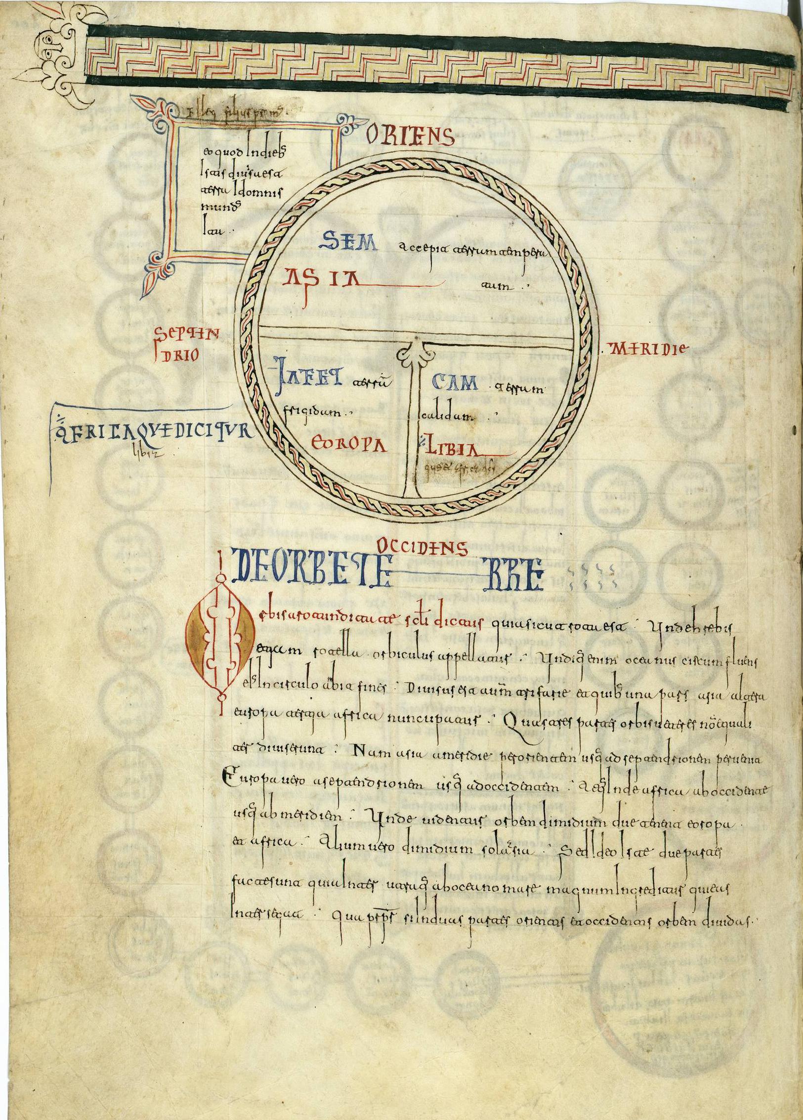
This may explain why medieval images of the world are often highly similar to images of cities and other elements in the world. Medieval world maps (mappae mundi) often take the form of the so-called “T-O map”, depicting the world in the form of a perfect circle (an “O”) surrounded by the ocean. The world is divided between Asia in the upper half, Europe and Africa in the lower half, separated by the Mediterranean Sea and the rivers Nile and Don in a T-form (fig. 1). The landmasses contain familiar cities and holy places, but also the dwellings of the ‘monstrous races’ more towards the edge. Later maps, such as the twelfth-century Hereford map, depict Jerusalem in the form of a perfect circle right in the middle, reflecting its status as the most important city of Christianity or ‘navel’ of the world (fig. 2).

Fig. 1. T-O map, belonging to Isidore of Seville’s chapter on the earth. Madrid, Real Academia de la Historia, Roda Codex, f. 200v (ca. 990). Source: Wikimedia Commons. 
Fig. 2. Hereford mappa mundi. Hereford cathedral, ca. 1250. Source: Wikimedia Commons.
Medieval maps of Rome, which became popular in the higher Middle Ages, convey a similar pattern, representing the city from above in circular form. It is surrounded by the Aurelian wall, recognizable from its city gates and battlements. The city is filled with some of its better-known buildings, both Christian and ancient, such as the Pantheon, the Pyramid of Cestius, and the Colosseum. A beautiful example can be found on p. 14 of the fourteenth-century manuscript from the Biblioteca Ambrosiana in Milan (C 246 Inf., accessible here): the circular form top centre has been identified as the Colosseum; right next to it is the Pantheon (identified by its vignette); bottom left we see a triangular structure reminiscent of the pyramid of Cestius; the port in the front has been identified as the Porta S. Petri.
Such maps of Rome were likely inspired by images of the heavenly Jerusalem, which likewise depict the city as a perfect circle (although there are also square-formed maps) surrounded by walls with gates and battlements (fig. 3). In maps of the earthly Jerusalem, which became popular during the crusades, the city is filled with both Christian monuments, such as the churches on the important spots of Jesus’ passion, and secular elements such as the houses of the citizens. Sometimes the main streets organize the city according to the pattern of the T-O map (fig. 4).
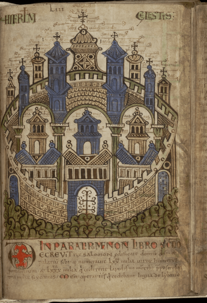
Fig. 3. The heavenly Jerusalem. Gent, Universiteitsbibliotheek. BHSL.HS.0092, ‘Liber Floridus’ by Lambert, canon of Saint-Omer, f. 65r (1121). Source: Universiteitsbibliotheek Gent. 
Fig. 4. T-O map of Jerusalem. Uppsala, Uppsala University Library, MS C 691, f. 39 (12th c.). Source: Wikimedia Commons.
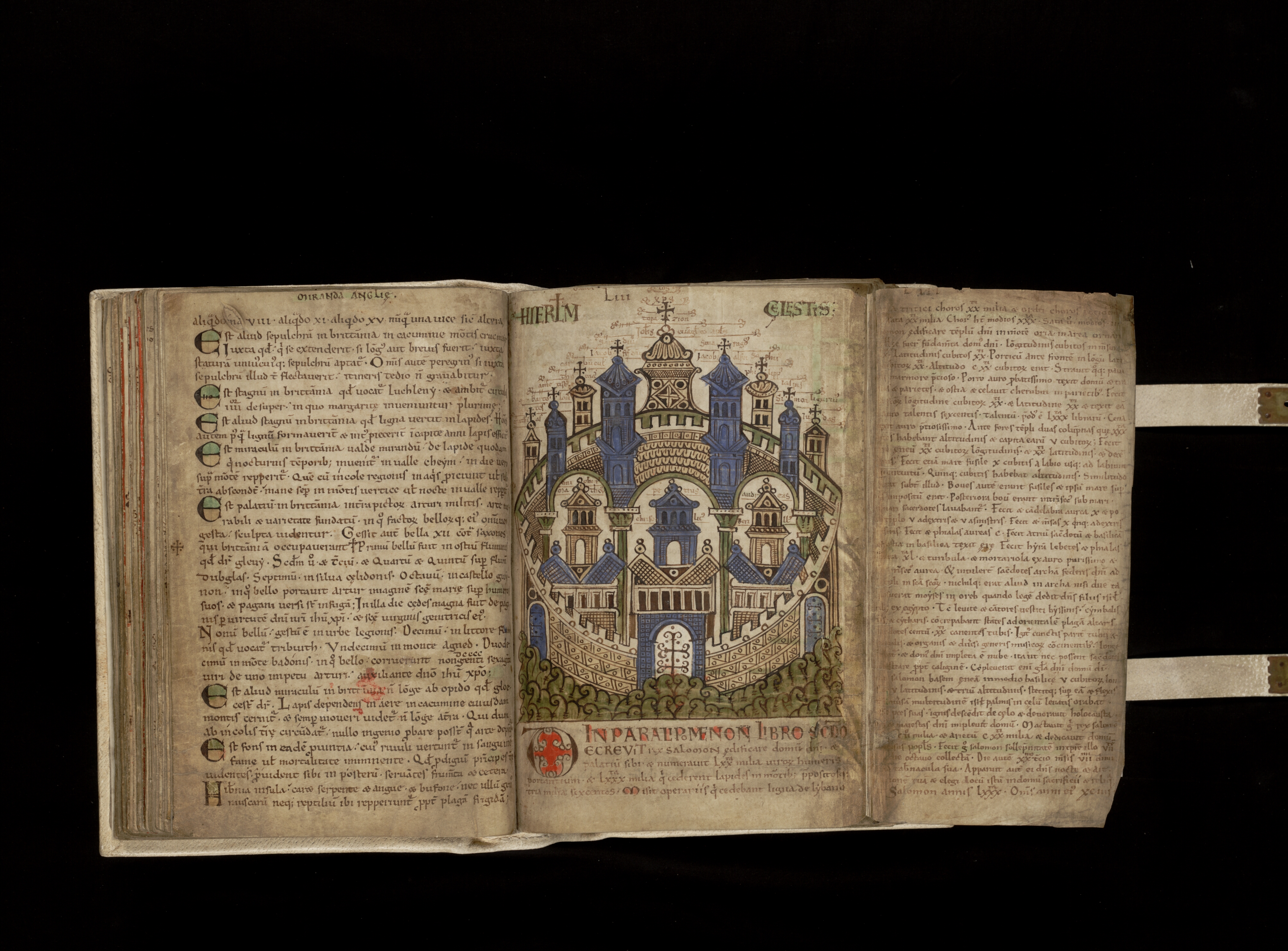
The same view also underlies textual representations of cities and the world. When I was writing this blog, I was studying the Itinerarium Einsidlense, a Carolingian collection of twelve walking routes (‘itineraries’) through Rome. It is transmitted once, in a ninth-century Carolingian manuscript from the Stiftsbibliothek Einsiedeln (fig. 5), which was most likely made in the ninth century in the Abbey of Reichenau (situated on an island in what is now called Lake Constance). The Itinerarium is a remarkable text, not least because of the form in which the routes are presented in the manuscript. The itineraries do not contain running text, but consist of lists of monuments, which are written in three columns at the left, right, and in the middle of the double page (‘bifolio’). The placement of the columns corresponds to the place where the traveler would see the monuments while walking through Rome: at the left- or right-hand side of the road, or—when s/he has to cross a square such as the Forum Romanum or a triumphal arch such as the one of Severus—in the front. The headings in s[inistra] (‘left’) and in d[extra] (‘right’) emphasize the location of the monuments in space, while titles in red capital letters (‘capitalis rustica’) indicate the beginning and end of the itineraries.
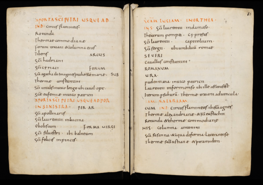
The Itinerarium depicts Rome according to the familiar pattern. Like in the later maps of Rome—the one of the Limbourg brothers (fig. 6) is a famous example—, there is a clear focus on the city walls: many of the routes begin or end at one of the main city gates, while the Itinerarium itself closes with a description of the Aurelian wall, including the amounts of towers, battlements, latrines, and windows on the various tracks between the main city gates. The tracks are mentioned in clockwise direction, which invokes an image of the city as a circular creation surrounded by walls. There is room for both the citizens and strangers, Christian monuments as well as antiquities: an important role is played by deaconries, guest houses for the sick and foreigners, which are mentioned in almost all routes. Scholarship suggests that some routes in the Itinerarium describe the course of the processions held at the main feast-days of the Roman religious calendar. One could say that the processions bring order in the Roman cityscape and render it a certain sacred core, defining which monuments served as a landmark or station on the route.

Ever since the rise of tourism in the nineteenth century, the Itinerarium has gained fame among scholars as one of the oldest ‘travel guidebooks’ to the eternal city, giving the traveler—often identified as a pilgrim—an overview of the most important sites in Rome. To be sure, Carolingians travelled to Rome, for instance, for political or diplomatic reasons or to go on a pilgrimage. Nevertheless, it is unlikely that the Itinerarium was meant to be used as a travel guidebook. Most people did not have the time and means to make such long journeys. And even if people travelled, it is unlikely that they took along parchment books such as the one containing the Itinerarium: it was simply too expensive for that. The book was rather intended to be read in the seclusion of the monastery, by monks with an interest in the city of Rome in its cosmopolitan form.
Medieval sources such as the Itinerarium and the other maps suggest that cosmopolitanism was not necessarily restricted to the happy few or connected to travelling. The cosmopolis as the ordered universe was visible in the direct surroundings, in the city in which you were living. The more privileged person could see the cosmopolis depicted in maps or read about it in books. Cosmopolitanism had something inclusive to it: anyone could see it, if you had an eye for it.
This may offer valuable perspectives on challenges brought about by the pandemic and even connect with trends that have tentatively started to emerge. Currently there is a growing awareness that travel is not necessarily connected with moving to the other side of the world. People have started to re-appreciate their immediate surroundings: the cities and villages they are living in with their hidden spaces and streets and green spots. “A walk to the park can feel like travel”. At the same time, technological developments helped the pandemic to realize what has been called a “cosmopolitan moment”, making people from around the globe interconnected more than ever. Today’s challenge is to reflect on the question how a similar inclusivity can be realized as in medieval times, so that that also people with less financial means and time can also be cosmopolitans at home, able to connect with others and to visit the nice places nearby.
This touches on what modern thinkers call “cosmological imagination”: the capacity to imagine how others live in the world near and far, and the questioning of the dynamics that govern the world and account for the differences between individuals. The medieval maps invite for such imagination by depicting places so distant that one could never go there in person, and at the same time displaying the more general principles that governing the world. The pandemic calls for a similar reflection and imagination. Which are the dynamics ordering the world beyond the four walls of our living room, and why does it look the way it looks like?
Further reading
- On medieval cosmopolitanism and world view: C.S. Lewis (1964), The Discarded Image: An Introduction to Medieval and Renaissance Literature (Cambridge); Keith D. Lilley (2004), ‘Mapping cosmopolis: moral topographies of the medieval city’, Environment and Planning D: Society and Space 22, 681-698;
- On modern cosmopolitanism: Stephen Toulmin (1990), Cosmopolis: The Hidden Agenda of Modernity (Chicago);
- On the medieval idea of the micro- and macrocosmos: Rudolf Allers (1944), ‘Microcosmus: From Anaximandros to Paracelsus’, Traditio 2, 319-407;
- On cosmopolitan imagination: Gerard Delanty (2009), The Cosmopolitan Imagination: The Renewal of Critical Social Theory (Cambridge);
- On the Einsiedeln Itinerarium: Franz Alto Bauer (1997), ‘Das Bild der Stadt Rom in karolingischer Zeit: Der Anonymus Einsidlensis’, Römische Quartalschrift für christliche Altertumskunde und Kirchengeschichte 92, 190-228; Anna Blennow (2019), ‘Wanderers and Wonders. The Medieval Guidebooks to Rome’, in Anna Blennow and Stefano Fogelberg Rota (eds), Rome and the Guide Book Tradition. From the Middle Ages to the 20th Century (Berlin) 33-88;
- On the Einsiedeln Itinerarium and liturgical processions: Rodolfo Lanciani (1891), ‘L’Itinerario di Einsiedeln e l’Ordine di Benedetto Canonico’, Monumenti Antichi 1, coll. 437–552.
